


Thread: Little Google Earth Trick
Results 1 to 5 of 5
|
|
-
#1 Little Google Earth TrickLife Is Good!

- Join Date
- May 2008
- Location
- Guangdong, China
- Posts
- 1,509
 12-11-2008, 04:03 AM
I found this interesting little plug in that will add some layers in Google Earth. Download this kml file and open it in GE. Select one of the layers like "Maps Opaque", and you get a nice layer of google map data.
They sure are making it hard to get lost now a days, but I'm sure I can still manage
If you have any other mapping or google earth tips, please add them to the thread.
Cheers!
ChinaV
-
Motorcycle Addict
- Join Date
- Apr 2008
- Location
- near Vienna, Austria
- Posts
- 809
12-11-2008, 12:53 PM
 Originally Posted by ChinaV

That's a really nice one!
Andy
-
#3 Create Maps from Google Maps with calibration dataMotorcycle Addict
- Join Date
- Apr 2008
- Location
- near Vienna, Austria
- Posts
- 809
12-11-2008, 03:10 PM
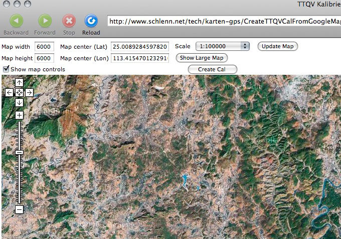
Carsten Jost from Germany developed a nice tool to create maps from Google Maps.
The following is tested in a Windows (XP Pro SP2, SP3) environment with the following:
- Internet Explorer 7, Firefox unfortunately doesn't work properly
- A screen capture software capable of making scrolling screen shots.
I use FastStone Capture V5.3 (the last free ware version, higher versions are payware). Download it from here or google for it.
Let's go!
1. Open the screen capture software
2. Visit this link or the mirror.

3. Select the are you want the map of. Three ways to do it:
the map control icons
pan with the mouse and zoom with the mouse wheel (don't use scale)
input coordinates and click update map
You can also set the map size in pixel, but don't set too high. It best up to the pixel size of your screen.
After changing the size click update map.
The scale input is only for the map which will be created!
4. Input the scale
The scale displayed can be changed to a bigger scale (smaller numbers), but only 3 steps bigger. E.g. 400,000 can be enlarged to 200,000 - 100,000 - 50,000.
5. Create map
Click "Show Large Map" and wait until it is fully loaded.
Select "scrolling capture" with FastStone (the little down arrow button)
Move the mouse on the map (a red frame will indicate the area to be captured) and click in it.
Wait until the capture is done and the file opens in the FastStone Editor.
Don't click in the map while capture is running!!!
Save the file.
6. Create calibration
return to the map window in IE
click the map and wait until the original map window reappears.
Don't click in the map!!!
A "Create Cal" button has been added to the controls - click it and the cal data are written under the map.
Copy the text to notepad
In line 2 "name":replace the "xxx" with the map name
In line 4 "fname" replace the xxx.png with the filename of your saved image file
save the text file in the same directory as the image with the same name + _png.cal
e.g. when the image file name is test.jpg the cal file name has to be test_png.cal
If anyone uses Touratech QV, the map can be imported without calibrating it.
For Ozi users this little tool can convert the cal file into Ozi format.
That's it. Sounds a little complicated but it's not really difficult.
Have fun. Any questions ? Feel free to contact me.
Andy
-
Life Is Good!
- Join Date
- May 2008
- Location
- Guangdong, China
- Posts
- 1,509
12-12-2008, 01:12 AM
Thanks Andy,
I was doing something similar by hand coding html pages for google maps, the site you pointed out is far better because it also gives you automatic calibration, Thank You! .
.
Just a note for the Mac user crowd. A great little application (freeware) for making screenshots of websites is Clip It. The nice thing about this program is that it captures a full web page, even the parts not shown on your screen.
For example:
This will make one giant 6000x6000 pixel screenshot, you can save it as JPG,PNG,TIF. Toggle the Map/Satellite/Terrain views and make a shot of each. You could combine these three in a program like photoshop and change the opacity of each layer for some cool effects. Maybe even move one of the layers a little differently to correct it's position
Cheers!
ChinaV
-
Life Is Good!
- Join Date
- May 2008
- Location
- Guangdong, China
- Posts
- 1,509
12-18-2008, 06:15 AM
One more cool layer to add to Google Earth. This file will display the maps from openstreetmap.org.
Cheers!
ChinaV


| « Previous Thread | Next Thread » |
| Bookmarks |
Bookmarks |


The Pillars of Salubrity:...
Yesterday, 12:12 PM in Off Topic Discussions