


Results 1 to 4 of 4
|
|
-
#1 CC's Geo-tagged image intro and archiveAdministrator-tron

- Join Date
- Apr 2008
- Location
- NoVA
- Posts
- 2,540
 04-22-2008, 01:26 PM
Thought I might take the opportunity to share a little of the GPS tracking and Geotagging I've done over the past few years in Western China. The great thing about combining both is the ability to co-locate useful and related info thereby shortening other peoples research process.
If anyone is interested in a basic introduction on this topic, please visit:
http://www.carlparker.com/WC_KMZ.html
Here you'll find a good basic run through of Google Earth, KML(Z) files and see some outrageous and, in a relative sense, never before seen landscapes of Western China. It's a wild and dangerous place that makes Death Valley look like a short walk through a desert (no offense to Death Valley but this place is BAD)
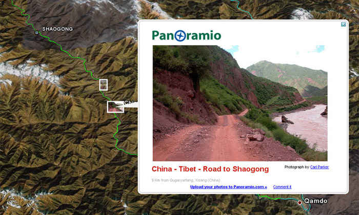
Or, if you just want to see the complete collection of geo-tagged pictures, you can head to my Panoramio site. Panoramio is a free service provided for people who want their geotagged images to appear on Google Earth. Photos go through a screening process and accepted images appear on the default Panoramio layer in GE.
Click here for Panoramio site
Once there you can browse anyone's images. If you're looking to do some ride-planning, this is a great place to start.
If anyone else has any geo-tagged image collections, I'm sure we'd all love to see them no matter how big or small!
CC---------------------------------------------------
Subscribe to the hippest, most happeneing Adventure Motorcycle Magazine around!
Adventure Motorcycle Dual Sport News Magazine
Help support MCM!! Buy "The Return - Riding Western China" DVD! -
http://www.motocyclops.com/buydvd/
Personal China travel info, photo and video site:
http://www.carlparker.com

-
C-Moto Guru
- Join Date
- Apr 2008
- Location
- Red China
- Posts
- 405
04-23-2008, 02:29 AM
How do you geo-tag your images?
-
Administrator-tron
- Join Date
- Apr 2008
- Location
- NoVA
- Posts
- 2,540
04-23-2008, 03:21 AM
First I put all the photos I want to geo-tag into a separate folder. Then I use Panorado Flyer which is a simple and FREE software that allows you to choose a location in Google Earth, then right click on your image file and Panorado will install menus in your pop-up, one of which says "Get location from Google Earth".

Click on that and it's instantly assigned.
For more info, download and a walk-through, check it out at:
http://www.panorado.com/en/PanoradoFlyer.htm
CC---------------------------------------------------
Subscribe to the hippest, most happeneing Adventure Motorcycle Magazine around!
Adventure Motorcycle Dual Sport News Magazine
Help support MCM!! Buy "The Return - Riding Western China" DVD! -
http://www.motocyclops.com/buydvd/
Personal China travel info, photo and video site:
http://www.carlparker.com
-
C-Moto Guru
- Join Date
- Apr 2008
- Location
- Red China
- Posts
- 405
04-23-2008, 03:36 AM
Thanks Carl. I'll try it out


| « Previous Thread | Next Thread » |
| Bookmarks |
Bookmarks |


What matters more to you on an 18+...
12-25-2025, 07:20 PM in Welcome to MCM!